
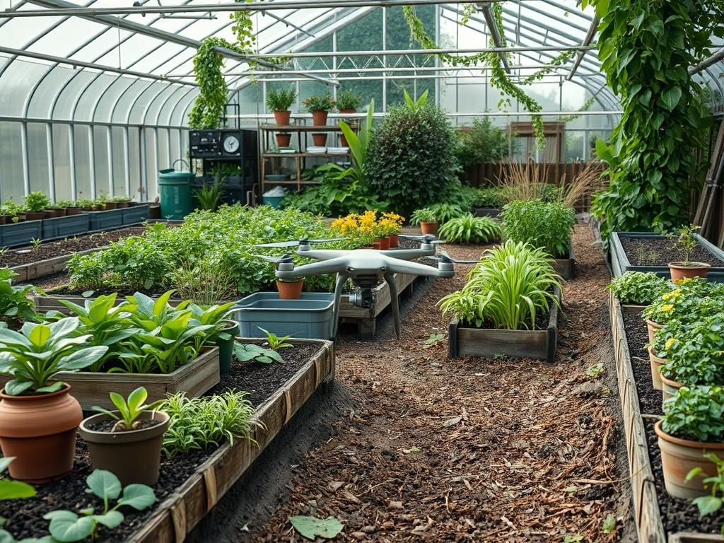
Traditional site surveying often fails to capture the intricate nuances of a property, leading to costly errors and missed opportunities for aesthetic cohesion. When professional landscape architects begin a project, they must grapple with varying microclimates, drainage patterns, and site constraints that are invisible from the ground. Drone Mapping for Gardens has revolutionized this initial phase by providing a comprehensive, high-resolution aerial view that traditional tape measures and levels simply cannot match. This technology allows for the creation of a digital twin, a precise 3D model of the existing terrain, which serves as the foundation for the entire design process. By integrating aerial data, designers can ensure that the outdoor functionality of a space matches the lifestyle of the inhabitants while significantly boosting curb appeal through intentional, data-driven placement of every element.
The primary challenge in modern landscaping is translating a two-dimensional vision into a complex three-dimensional environment. Drones equipped with High-Definition Cameras and RTK GPS sensors can map an entire acre in minutes, saving hours of manual labor. This data is then converted into Orthomosaic Maps and Contour Maps, which reveal the true hydrology of the land. Understanding where water naturally pools or flows is essential for climate-smart design. In regions prone to drought or heavy rainfall, this accuracy determines the success of the project. A well-planned garden is not just a collection of plants; it is a holistic system where the irrigation software and the physical layout work in tandem to create a sustainable environment.
Landscape Design Principles
Symmetry and visual balance are the hallmarks of a professionally designed estate, but achieving them on uneven terrain is notoriously difficult. Using drone mapping, we can establish perfect sightlines from the primary windows of the home to the distant focal points in the garden. By analyzing the Digital Elevation Model (DEM), a designer can determine the exact height needed for retaining walls to create level terraces. These elevation layers add depth and drama to the landscape, allowing for the transition between intimate seating areas and expansive lawns.
Focal points, such as a large granite water feature or an ancient specimen tree, must be positioned to draw the eye without overwhelming the space. Drone data allows for virtual “walk-throughs” before a single shovel hits the dirt. We can move a virtual tree a few feet to the left or right to see how it affects the view from the patio. This precision extends to the planning of walkways and paver paths. By mapping the natural foot traffic patterns visible from the air, we can design paths that are both beautiful and functional, ensuring that the polymeric sand joints and stone placement align with the natural flow of the site.
Irrigation planning also benefits immensely from aerial mapping. Instead of a one-size-fits-all approach, we use Multispectral Sensors on drones to identify existing “hot spots” where the soil currently lacks moisture. This allows for a zone-based irrigation design that delivers precise amounts of water to different areas, reducing waste. The final result is a balanced landscape where the hardscaping and softscaping exist in a state of harmonious equilibrium, supported by invisible but rigorous technical planning.
Plant and Material Selection
Selecting the right materials and flora requires more than just an internal eye; it requires data regarding sun exposure and soil health. Below is a selection of plants frequently utilized in modern, high-end landscape designs that benefit from the precise placement enabled by mapping.
| Plant Type | Sun Exposure | Soil Needs | Water Demand | Growth Speed | Maintenance Level |
| :— | :— | :— | :— | :— | :— |
| Emerald Green Arborvitae | Full Sun | Well-drained | Moderate | Medium | Low |
| Lavender Munstead | Full Sun | Sandy/Rocky | Low | Fast | Low |
| Limelight Hydrangea | Sun to Part Shade | Rich/Moist | High | Fast | Medium |
| Mexican Feather Grass | Full Sun | Poor/Well-drained | Very Low | Fast | Low |
| Boxwood Green Velvet | Full Sun to Shade | Loamy | Moderate | Slow | High |
| River Birch | Full Sun | Acidic/Wet | High | Fast | Medium |
The choice of hardscape materials is equally critical. For modern landscapes, natural bluestone or porcelain pavers offer a sleek aesthetic. In more traditional settings, tumbled brick or flagstone provide a timeless feel. Drone mapping helps calculate the exact square footage needed for these materials, reducing waste and ensuring that the base gravel and bedding sand are ordered in the correct quantities.
Implementation Strategy
The transition from a digital map to a physical garden requires a systematic implementation strategy. It begins with site preparation, where a skid steer or mini-excavator is used to grade the land according to the contour lines established by the drone. Grading is the most critical step; if the slope is off by even a few degrees, water will migrate toward the home foundation rather than toward the French drains or bioswales.
Once the grading is finalized, the hardscaping begins. We use a laser level to double-check the drone data as we install retaining walls and patios. The installation of edging follows, which defines the borders between the lawn and the planting beds. This edging should be crisp and permanent, using materials like stepped steel or heavy-duty aluminum.
Next, the irrigation lines and low-voltage lighting cables are laid. Because we have a precise map, we can avoid cutting into existing utility lines. The final phase is the planting of the “bones” of the garden, which are the large trees and shrubs, followed by the perennials. Every planting hole is amended with organic compost and mycorrhizal fungi to facilitate root growth. Finally, a three-inch layer of hardwood mulch is applied to suppress weeds and retain moisture. This layer should be kept away from the trunks of the trees to prevent rot, a common mistake in amateur installations.
Common Landscaping Failures
The most frequent failure in landscaping is poor drainage planning. Without the aerial perspective provided by Drone Mapping for Gardens, it is easy to miss subtle dips in the terrain. These areas inevitably become mud pits that drown plant roots and attract mosquitoes. Another common error is root overcrowding. Designers often plant for the way a garden looks on day one, neglecting to account for the mature spread of the plant. A drone orthomosaic allows us to overlay the mature circles of trees to ensure that, ten years from now, they are not competing for the same light and nutrients.
Soil compaction is another silent killer. During construction, heavy machinery can crush the soil structure, leaving it as hard as concrete. Proper implementation requires mechanical aeration before planting to ensure that oxygen can reach the root zones. Furthermore, improper spacing of irrigation heads leads to “dry spots” and “dead zones.” By using a drone to check the spray patterns of the rotor heads, we can ensure total coverage and prevent the catastrophic loss of a new lawn.
Seasonal Maintenance
A landscape is a living organism that evolves throughout the year. In the spring, the focus is on renewal. This includes power washing patios, applying pre-emergent herbicide, and performing the dormant pruning of late-summer flowering shrubs with bypass loppers. This is also the time to check the drone-based map for any new erosion that may have occurred during the winter thaws.
Summer management is largely about water and stress mitigation. We monitor the garden for signs of heat stress and adjust the irrigation controller settings accordingly. Raising the mower blade to a height of four inches helps the grass shade its own roots and stay green during peak heat. Autumn is for clean-up and preparation. We use leaf blowers to clear debris and apply a high-potassium fertilizer to help plants harden off for the cold. Winter is the season for structural maintenance. We check the integrity of retaining walls and lighting fixtures, ensuring that the garden remains a beautiful, sculptural element of the property even when the leaves have fallen.
Professional Landscaping FAQ
How does drone mapping improve garden design accuracy?
Drones capture thousands of data points to create high-resolution 3D models. This eliminates manual measurement errors and provides precise topographical contours, ensuring that every element of the hardscape and softscape fits perfectly within the existing legal and physical boundaries of the site.
Can drone mapping help with existing drainage issues?
Yes, drone-generated topographical maps highlight the exact flow of water across a property. By identifying low spots and natural runoff channels, designers can pinpoint where to install catch basins or swales to prevent erosion and water damage to the home.
Is drone mapping expensive for small residential gardens?
While there is an initial cost, it often pays for itself by preventing expensive planning errors. Accurate measurements reduce material waste in pavers and mulch, while the speed of data collection reduces the billable hours required for traditional land surveying techniques.
What is the best way to prevent weeds in new beds?
Proper implementation involves a multi-layered approach. Start by clearing all existing vegetation, then install a heavy-duty landscape fabric or a thick layer of cardboard. Finally, apply at least three inches of shredded hardwood mulch to block sunlight from reaching weed seeds.
When should I prune my flowering shrubs?
Timing depends on the species. Shrubs that bloom on “new wood” should be pruned in late winter or early spring. However, those that bloom on “old wood” should be pruned immediately after their flowers fade to avoid cutting off next year’s buds.