
Every landscape project begins with a vision, yet the distance between an initial sketch and a mature, thriving ecosystem is often fraught with unpredictable variables. Traditional methods of planning rely heavily on static drawings and optimistic projections. However, the emergence of Digital Twin Gardening offers a paradigm shift in how we manage outdoor environments. A digital twin is a dynamic, virtual replica of your physical land, integrated with data that mirrors real world conditions. By simulating growth cycles, solar orientation, and soil hydration, property owners can bypass the expensive trial and error phase. This approach ensures that every hardscape element, from retaining walls to patios, functions in harmony with the biological demands of the chosen flora.
The primary challenge in site development is the passage of time. A tree planted today will look vastly different in 15 years, potentially casting shadows that kill off understory plants or lifting concrete walkways with its root system. Digital twin technology allows us to fast forward these biological processes to see the future of the landscape. This level of precision is essential for maximizing curb appeal and ensuring that outdoor living spaces remain functional as they age. Whether you are managing a small urban courtyard or a sprawling multi acre estate, the goal is to create a sustainable, resilient environment that responds intelligently to the local climate.
Landscape Design Principles
Successful landscaping is rooted in the marriage of aesthetics and engineering. When building a digital twin, we start with the principle of visual balance and symmetry. Symmetry does not always mean a mirror image; rather, it refers to the distribution of visual weight across a focal point. In a virtual model, you can test how a 3D scanned specimen of Acer palmatum balances a heavy stone hearth on the opposite side of a terrace. Using digital tools, we can adjust the placement of focal points to ensure they draw the eye without overwhelming the natural surroundings.
Elevation layers are perhaps the most critical component of a functional digital twin. By inputting accurate topographical data, typically gathered through Lidar or Photogrammetry, we can visualize how water moves across the site. This allows for precise irrigation planning and the strategic placement of French drains or bioswales. We also focus on the concept of mass and void. The “mass” consists of dense plantings and structures, while the “void” represents open lawn or paved areas. A digital twin allows us to walk through these virtual voids to test the ergonomics of 3 foot wide walkways and the clearance of overhead pergolas before a single stone is laid.
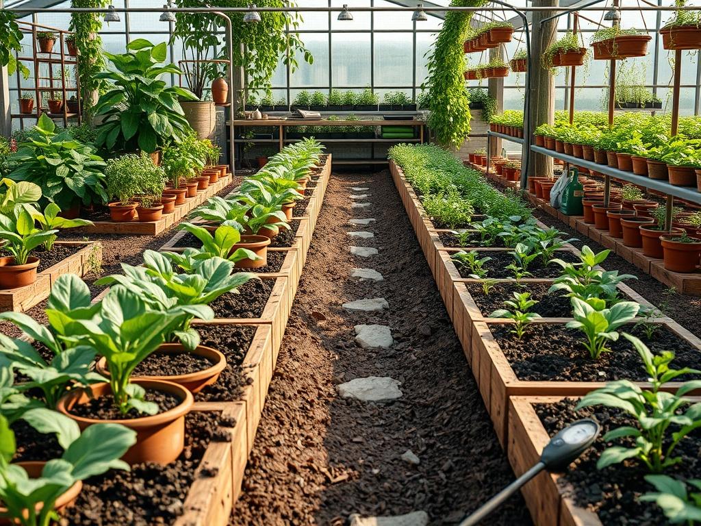
Plant and Material Selection
The following table outlines common selections used in growth simulations to ensure long term viability.
| Plant Type | Sun Exposure | Soil Needs | Water Demand | Growth Speed | Maintenance Level |
| :— | :— | :— | :— | :— | :— |
| Taxus baccata | Full Sun to Shade | Well-drained | Moderate | Slow | Low |
| Pennisetum alopecuroides | Full Sun | Loamy/Sandy | Low | Fast | Moderate |
| Buxus sempervirens | Partial Shade | Rich/Moist | Moderate | Slow | High |
| Echinacea purpurea | Full Sun | Poor to Average | Low | Medium | Low |
| Hydrangea macrophylla | Shade | Moist/Acidic | High | Fast | Moderate |
| Lonicera nitida | Full Sun/Partial | Any | Medium | Fast | High |
Selecting the right materials extends beyond plants. In a digital twin, we assign specific properties to hardscape materials. A flagstone path will have different heat absorption and runoff coefficients than decomposed granite. By simulating these properties, we can predict how a southeast facing terrace will feel during a mid July afternoon. This data driven selection process prevents the use of materials that might crack under local frost heave or fade under intense UV exposure.
Implementation Strategy
The transition from a virtual model to a physical garden requires a structured implementation strategy. The first step involves a comprehensive site survey. Using a digital laser measure or a drone, capture the exact coordinates of existing structures, utility lines, and boundary fences. This raw data is imported into architectural software like Sketchup or AutoCAD, forming the “bones” of the digital twin. Once the static elements are in place, we overlay environmental data, including historical weather patterns and soil pH test results.
Next, we address grading and drainage. In the digital space, use a digital level simulation to ensure the ground slopes away from the home at a minimum of 2 percent grade. If the terrain is steep, the model will indicate where retaining walls are necessary to prevent erosion. After the grade is established, we layer the hardscaping. This includes the installation of geotextiles under gravel beds and the precise mapping of a subsurface drip irrigation system.
The final stage of the digital implementation is the biological projection. We “plant” digital assets into the model, ensuring each species has a 36 inch or larger spacing budget based on its mature width. We then run a time lapse simulation. This step reveals if a fast growing Salix babylonica will encroach on power lines or if mulch depth of 3 inches is sufficient to suppress weeds in a specific area. Once the simulation confirms the layout is viable, the physical labor begins.
Common Landscaping Failures
Even with advanced planning, certain failures recur in the industry. The most frequent issue is improper drainage. When water is not directed away from foundations and root zones, soil becomes anaerobic, leading to root rot and structural instability. A digital twin can identify “dead zones” where water collects. Another common mistake is root overcrowding. It is tempting to plant closely for immediate impact, but without considering the mature spread, plants will eventually compete for nutrients and light, leading to stunted growth or death.
Soil compaction is another silent killer of high end landscapes. During construction, heavy machinery can compress the earth, destroying the pore spaces necessary for oxygen and water infiltration. Using a digital twin, we can plan construction access routes that minimize the footprint of heavy equipment. Finally, irrigation inefficiencies often stem from “clamshell” coverage where water hits hard surfaces instead of the root zone. Digital simulations allow us to map the exact throw of each irrigation nozzle, ensuring 100 percent efficiency and reducing water waste.
Seasonal Maintenance
To keep both the physical garden and its digital twin in peak condition, a seasonal management schedule is required. In the spring, the focus shifts to soil health and rejuvenation. We recommend applying 1 inch of high quality compost and checking the calibration of the irrigation controller. This is also the time to update the digital twin with any winter dieback data or new growth measurements.
Summer maintenance centers on moisture management and pest control. During extreme heat, the digital twin can help calculate the increased evapotranspiration rates, suggesting adjustments to watering durations. In autumn, the priority is cleanup and preparation. This involves pruning deciduous species and applying a fresh layer of hardwood mulch to insulate roots. Finally, winter is the season for structural review. Without the distraction of foliage, you can use the digital twin to analyze the “winter interest” of your landscape, ensuring that evergreen structures and hardscape details provide visual appeal even in the dormant months.
Professional Landscaping FAQ
How does a digital twin improve plant health?
It simulates solar movement throughout the year. This ensures light hungry species are not trapped in shadows as the sun angle changes. It also predicts water needs based on specific soil drainage and local weather data.
What tools do I need for a DIY digital twin?
Start with a high resolution smartphone camera for photogrammetry and a 3D modeling app like SketchUp. Professional consultants often use Lidar scanners and specialized software like Realtime Landscaping Architect for higher accuracy and growth physics.
Can I simulate my garden’s growth over ten years?
Yes. Modern landscape software allows you to adjust a “growth slider.” This shows the transition from a newly installed 15 gallon tree to its full mature height and canopy spread, preventing future overcrowding.
Is irrigation mapping really necessary for small yards?
Absolutely. Precise mapping prevents overwatering and protects your home’s foundation from moisture damage. It also ensures that expensive ornamental plants receive the exact gallonage required for their specific species and soil type.
What is the most important data point for a simulation?
Accurate topography is paramount. Without knowing the exact elevation changes of your property, you cannot accurately predict water runoff or soil erosion. This data forms the literal foundation of every successful landscape growth simulation.